LLD: Otmoor
Assessment area map: Otmoor
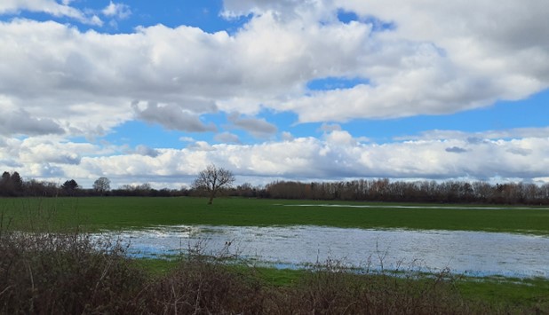
Lowlands within Otmoor Nature Reserve
×![]()
Lowlands within Otmoor Nature Reserve
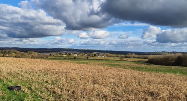
Views north-east towards Otmoor from near Noke
×![]()
Views north-east towards Otmoor from near Noke
Context
The assessment area lies to the south-east of Cherwell District and is defined to the west by the administrative border with Aylesbury Vale District, and to the south by the administrative border with South Oxfordshire District. The assessment area comprises the Otmoor wetlands and surrounding low-lying farmed vale landscapes to the south-west of the M40. The adjacent land to the west, within the Vale of Aylesbury District, is designated locally as part of the ‘Brill – Winchendon Hills’ Area of Attractive Landscape (AAL), although this relates to a series of undulating hills and ridges very distinct in character to the assessment area. The adjacent land to the south, within the South Oxfordshire District, has been proposed as part of the ‘East Oxford Hills and Otmoor floodplain’ Local Landscape Designation (LLD).
The assessment area lies entirely within LCA 8: Otmoor Lowlands described within the Cherwell Landscape Character Assessment.
Evaluation
Local distinctiveness and sense of place
Considerations
- Is landscape rare/unique or special in the local context, and/or does it have a strong sense of place derived from its combinations of elements?
- Does it contain character/features or elements which are considered to be important, typical or rare examples?
- A landscape may have additional distinctiveness if it has a strong association with the character of a particular settlement, whether through strong views from the settlement or through providing a clear sense of arrival at the settlement.
Analysis
- Principally a distinctive flat and open landscape contrasting with the elevated and wooded Coral Rag hills which rise and contain the lowlands to the south and south-east; topography in the south-east and west of the area rises to form part of the hills around Horton-cum-Studeley and Noke respectively.
- Flat, low-lying wet meadows and pastures associated with the River Ray floodplain form a locally recognisable features that are rare across the wider area.
- Lowlands associated with the River Ray and New River Ray strongly contribute to the landscape setting of several small settlements which occupy slightly higher ground that skirts the wetlands. This includes Noke, Oddington, Charlton-on-Otmoor, Fencott and Murcott.
- A diverse range of bird habitats within Otmoor Nature Reserve support varied birdlife, including Starling murmuration which appears above the wetlands, providing a unique experiential aspect of the landscape.
- Smaller-scale fields are defined by overgrown hawthorn hedgerows and willow-lined streams and ditches giving some structure and enclosure to the landscape.
Landscape quality (intactness/condition)
Considerations
- What is the physical state of the landscape in terms of its intactness and the condition of individual natural and cultural elements?
Analysis
- There is a strong sense of ecological integrity owing to the large areas of lowland meadows, wetlands and grasslands.
- Large woodland blocks to the south, most of which are ancient – Whitecross Green Wood, Noke Wood and Prattie Wood –contribute to the ecological integrity of the landscape.
- Fields are defined by a network of hedgerows which are largely in good condition, albeit with some gaps in places; the field pattern is generally of a smaller scale than other parts of the wider LCA.
Scenic qualities and perceptual aspects
Considerations
- Does the landscape appeal to the senses, primarily visual but also considering perceptual and aesthetic qualities such as sense of tranquillity and remoteness.
Analysis
- Localised rises in topography and where roads are raised above the surrounding levels allow extensive uninterrupted views across the flat, low-lying landscape giving rise; longer views are backdropped by wooded higher ground to the west, south and south-east.
- Elsewhere, views tend to be limited by riverside and roadside vegetation.
- Whilst settlements occupy localised high points in the landscape they tend to be visually screened by trees, both within and surrounding the villages. However, church towers are sometimes visible above this and provide localised focal points in views.
- South-west and south-east corners of the LLD are more wooded and have a good sense of enclosure despite the higher elevation of the slopes.
- The area has a strong rural quality with large areas remaining free from development resulting in a sense of tranquillity and remoteness, particularly within the reserve, as demonstrated by CPRE tranquillity mapping.
- The majority of the area has relatively dark skies at night, as demonstrated by CPRE night blight mapping.
Natural qualities
Considerations
- Are there natural attributes that contribute to the value of the landscape?
- Consider distinctiveness of landforms and the presence and extent of semi-natural habitats and wildlife that contribute to sense of place.
- Consider any particular functional value associated with the natural landscape, particularly in the healthy functioning of the landscape.
- Consider landscapes and landscape elements that have strong physical or functional links with an adjacent national landscape designation, or are important to the appreciation of the designated landscape and its special qualities.
Analysis
- Includes Otmoor Nature Reserve and Otmoor SSSI and contains a number of priority habitats including coastal and floodplain grazing marsh, lowland meadows, and good quality semi-improved grassland; these features provide ecological value and contribute positively to the landscape.
- The area contains large blocks of woodland in the south-east and west which add to its landscape value, providing variation in what is otherwise open expansive area of lowland marshland. Many of the deciduous woodlands are ancient.
- An area of low-lying Quaternary alluvium, enclosed to the south by gentle Jurassic mudstone slopes around Noke and Hornton-cum-Studley; this gives a visible expression of the underlying geology and confers a distinct character.
Cultural qualities
Considerations
- Are there cultural attributes that contribute to the value of the landscape?
- Consider the extent to which the landscape displays time depth: either in terms of the presence of natural features, historic field patterns or heritage assets that contribute to landscape character.
Analysis
- The Oxfordshire Historic Landscape Characterisation (HLC) identifies much of the area as comprising post-war/modern ‘planned enclosures’ and ‘prairie / amalgamated enclosure’, with some post-medieval ‘reorganised enclosures’, often near settlements. Parts of Otmoor remain as grazed marshland which reflects the traditional land use and, along with the areas of ancient woodland, provides a sense of time-depth.
- The dispersed farmsteads and nucleated settlements reflect the historic settlement pattern, providing a sense of historic character and time-depth. Charlton-on-Otmoor is covered by a Conservation Area designation and includes the Grade I Listed Building St Mary’s Church. There are a number of Grade II Listed Buildings throughout the settlements including Church of St Barnabas at Horton-cum Studley. The landscape provides a strong setting to these features.
Recreation value
Considerations
- Is there evidence that the landscape is valued for recreational activity where the experience of the landscape is important?
Analysis
- The area is crossed by an extensive network of public rights of way, including footpaths, bridleways, and part of the Oxfordshire Way, all of which provide valuable access to the landscape.
- The 485-hectare Otmoor RSPB Nature Reserve is one of the largest inland wetland complexes in the country and a haven for birdlife, and is popular destination for birdwatchers.
Associations
Considerations
- Is the landscape associated with particular people such as artists or writers or events in history that contribute to its character?
Analysis
- The idea of the chess board in Alice in Wonderland is said to have come to Lewis Carroll at the top of Noke Hill looking down at the grid pattern of fields at Otmoor divided by hedges and ditches.
Summary of landscape value and qualities
Aspects of landscape value (qualities and/or elements/features/areas of value) are:
- A distinctive flat and open landscape contrasting with the higher Coral Rag hills which rise to the south, west and south-east.
- Expansive uninterrupted views across the flat low-lying landscape from localised rises in topography and where roads are raised above the surrounding levels; the elevated topography in the south, west and south-east creates a sense of enclosure and forms the wooded horizons in the in views.
- Flat, low-lying wet meadows and pastures which form locally recognisable features that are rare across the wider area.
- Provides a distinctive landscape setting to several small historic settlements which skirt the floodplain landscape.
- Several scattered blocks of woodland, including ancient woodland, and areas of coastal and floodplain grazing marsh and lowland meadows provide ecological integrity and contribute positively to the landscape.
- A rare surviving example of inland grazed marshland which reflects the traditional land use and, along areas of ancient woodland and dispersed historic settlements, provides a sense of historic character and time-depth provides important wildlife habitat.
- Large areas remaining free from development resulting in a strong rural quality and sense of tranquillity and remoteness.
- An extensive network of public rights of way and Otmoor RSPB Nature Reserve provide valuable access to the landscape.
Based on the above, it is considered that the assessment area has ‘above ordinary’ landscape value.
The boundaries of the former AHLV would be appropriate for a reinstated LLD, as shown on the Map at the top of the page.
Landscape guidelines
Landscape management
- Retain the role of Otmoor as distinctive landscape contributing to a sense of place.
- Ensure open character of flat lowlands is maintained, including the contribution to the distinctive setting of historic villages.
- Retain and enhance woodland cover on higher ground and explore opportunities to expand and connect existing areas of woodland through natural regeneration and/or small-scale planting to strengthen landscape character and bring benefits for biodiversity.
- Conserve and manage the Ancient Woodland sites and promote information and understanding about their historical and ecological importance. Maintain and enhance their role as a wooded backdrop to the south of Otmoor.
- Encourage the management and strengthening of hedgerows particularly in areas where there are gaps; seek to maintain and enhance remnant areas with a smaller-scale field pattern.
- Protect the experiential qualities of the landscape, particularly the high levels of tranquillity and intact rural character.
- Identify key viewpoints from publicly accessible locations and promote the retention and enhancement of the distinctive long-range views across Otmoor.
- Encourage and enhance opportunities for public access to the Otmoor RSPB Reserve with education and new access agreements where appropriate.
Development management
- Avoid development that would intrude on locations currently remote from urbanising influences, either through its size, scale or character, or its impact on levels of activity (such as traffic generation).
- Maintain the characteristic sparse pattern of development by avoiding large-scale development. Where Conservation Areas or Listed Buildings retain a strong relationship with open land, avoid development that would weaken this link.
- If development is proposed look to minimise its impact through careful design, in terms of siting, form, scale, massing, materials and the use of locally characteristic planting.
- Seek to reduce lighting impacts and avoid any reduction in tranquillity; minimise the use of lighting, in particular blue light emissions, and use shielding and sensors effectively to direct lighting downwards in relation to development visible on higher ground.
- The Oxfordshire Treescape Project considers that sites with multiple benefits for woodland opportunities are located in the area, particularly near Noke, between Horton-cum-Studley and Whitecross Green Wood, and near Mucott and Fencott. The project also identifies multiple benefits for grassland opportunities near Noke and between Horton-Cum-Studley and Whitecross Green Wood.